This is event is characterized by a low solar wind speed of 275 km/s, a
small positive ![]() and
only slight sign changes in the
and
only slight sign changes in the ![]() component of the IMF during the
period. IMP8 is located in the tail region.
The
component of the IMF during the
period. IMP8 is located in the tail region.
The ![]() index at the time of the event was below 1.0.
index at the time of the event was below 1.0.
A large area of backscatter has been recorded during this event from both
radars. Visible in Figure 5.64 are three
distinct regions of double-peak spectra occurrences.
One patch is centered at about ![]() E and
E and ![]() N, an extended band
stretches from
N, an extended band
stretches from ![]() E and
E and ![]() N in a curve southeast to
N in a curve southeast to
![]() E and
E and ![]() N and a patch is located further south, centered at
about
N and a patch is located further south, centered at
about ![]() E and
E and ![]() N.
N.
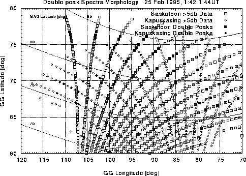
Figure 5.64: Map of spectral findings from the Saskatoon and Kapuskasing radars:
25 Feb/95
As can be seen in Figure 5.65, the track of the satellite is situated very
well for observations. It enters the south-east patch of double-peaked spectra at
about ![]() , exits at about
, exits at about ![]() and reenters the extended band at
and reenters the extended band at
![]() , leaving at
, leaving at ![]() .
.
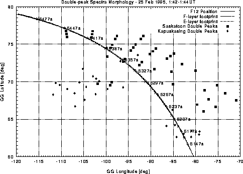
Figure 5.65: Peak-map with overlaid flight path of the DMSP F12 satellite: 25
Feb/95
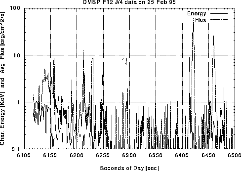
Figure 5.66: Average electron energy and flux determined from SSJ/4 instrument
measurements: 25 Feb/95
It is apparent from Figure 5.66 that both periods include
satellite observations of increased flux.
The low energy precipitation begins at about ![]() with
a sharp peak.
The features are more apparent in Figure 5.67 where it can be seen that
F-layer ionization is high from about
with
a sharp peak.
The features are more apparent in Figure 5.67 where it can be seen that
F-layer ionization is high from about ![]() to
to ![]() and again
from
and again
from ![]() to
to ![]() . Both periods correspond to regions of double-peaked
spectra seen with the radar.
. Both periods correspond to regions of double-peaked
spectra seen with the radar.
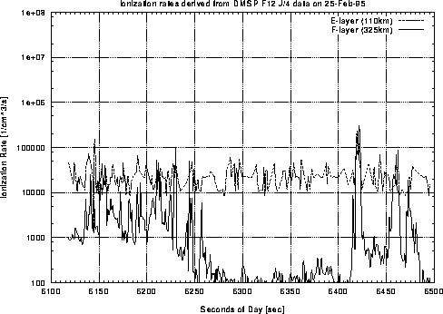
Figure 5.67: Estimated ionization rates at E- and F-layer heights determined from electron
spectra measurements: 25 Feb/95
The conductance graphs of Figure 5.68 show little E-layer conductance changes.
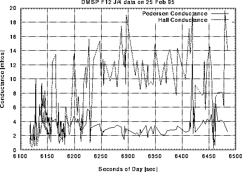
Figure 5.68: Estimated E-layer conductivities from the Robinson model: 25 Feb/95
The velocity map of Figure 5.69 is characterized by low velocities and complex convection patterns. The regions of double-peaked spectra are present in all areas of the flow map and do not seem to correspond to a particular region.
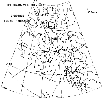
Figure 5.69: SuperDARN velocity map: 25 Feb/95